Wednesday, February 27, 2013

MacRitchie Trail

The MacRitchie Trail is a trail that goes around MacRitchie Reservoir. It can be access from a few places. The one I have chosen is at the Junction of Lonie Road and Thomson Road. The available bus service are 52, 74, 93, 130, 122, 156, 157,162, 165, 166, 167, 852,855, and 980. The nearest MRT is Caldecott.

On entry you will see a drain where the reservoir releases the water. Today happened to be when the water is released due to heavy rain last night.
Just follow along the left side of the drain to access to the trail. The 0KM marker is actually further down the trail. Note the color marking. It is actually indicating the train distance by specific trails. I chose the trail that is marked yellow. Along the way you will see markers indicating the distance travelled. Just keep looking for the yellow color marker.
The trail around this area has a lot of pebbles but is quite dry even after yesterday's rain. Just further down you will see two junctions. Don't turn into the side trails.

Keep going along the trail till you hit Island Club Rd. Here you will need to go on the road for a short distance before the trail begins again

The next trail entrance is on the left hand side of the road. Go into the trail and you will reach the Ranger Station where the HSBC Tree Top walk is. Since it is not part of the yellow trail, we will miss it this time.

There are toilets available at the Ranger Station. Make sure you use it as it will be the only available toilet in the trail till we reach back the starting point.

A few of the pictures does not have Exif data and is not accessible from Blogger. It is probably due to me using Wikiloc to take waypoint pictures. However, the pictures can be seen in Picasa Web. I will provide the link later.

There is a trail junction after Ranger Stn. Be careful not to end up on the trail to Riffle Range Trail. Keep to the left trail.


The next point of interest is the Jerutong Tower. If you are not careful you will miss it. The iron tower is painted green and is surrounded by shrubs. The trail will actually go around it. The top of the tower is actually above the tree canopy. You can have a clear view of the Reserve. I took a picture on top of it looking down at the trail. It is a bit wavy right at the top of the tower. You can actually feel the sway as you move around. If you are afraid of heights, you might want to give it a miss.

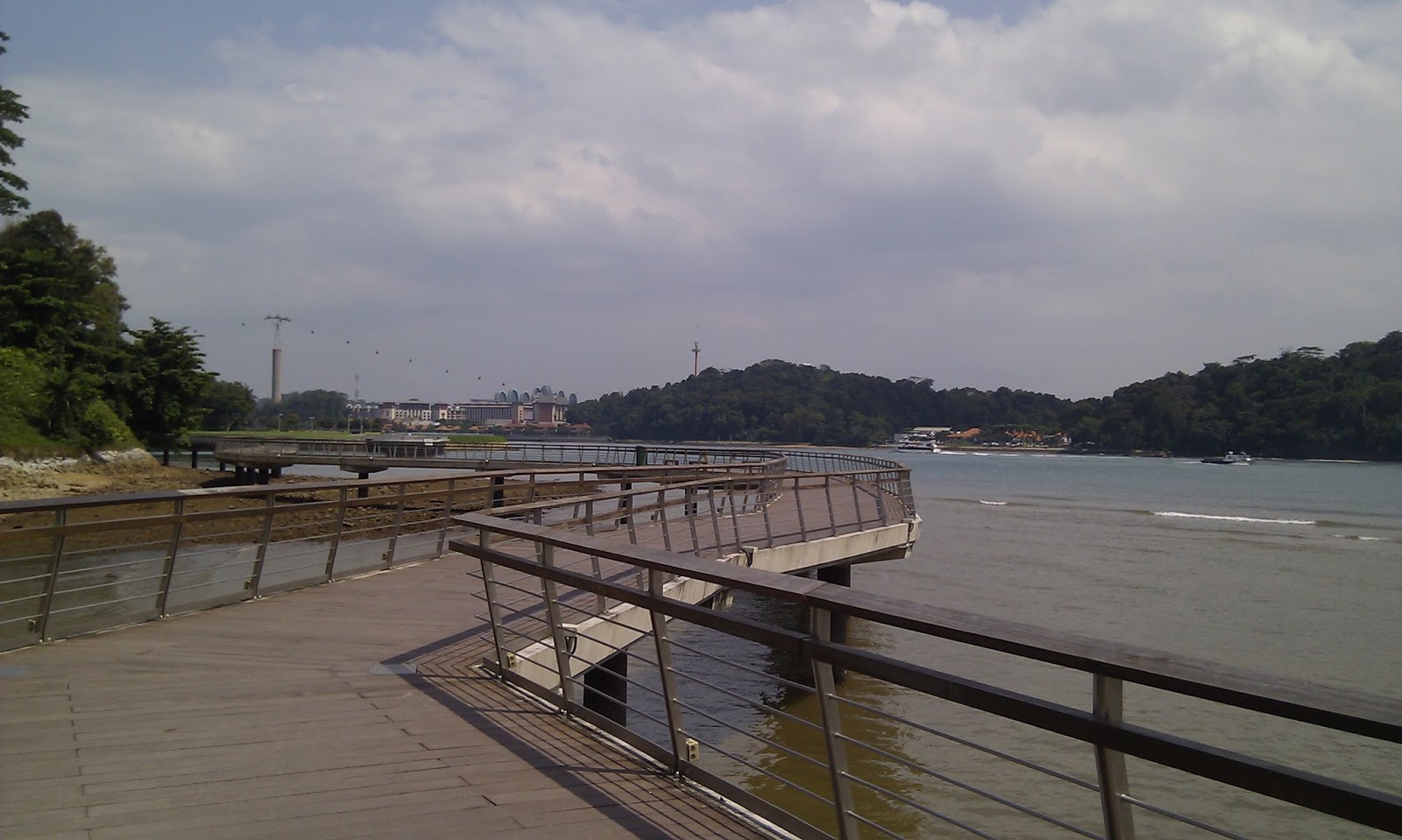
After the tower, you will be walking on wooden bridges that goes slightly above the ground. It will go all the way till the golf course. Along the way there was a fallen branch that blocked almost entirely bridge. On the left is a pool of water, on the right is the branch. I had to squeeze between the two by doing the crab walk while almost squatting down.

Further down the bridge there is a decayed bridge leg. The bridge end up becoming wavy when you walk on it. I guess the part of the bridge will break if nothing is done to it. I have reported to NParks and hope they will solve the two issue immediately.

Walking along the Island Country Club (golf course) is hot as there is no shade. It is a welcoming relief when wooden bridges are again available after the golf course.
Further down the bridge, the authority purposely leave a tree branch hanging over the bridge by lowering the bridge itself to go under it. Good idea, otherwise it become monotonous.
Near the end of the trail there is a performance pavilion and a wading trail. The wading trail is actually a bridge that goes slightly underwater so that you can get your feet wet. It is for cooling down after a long and hot walk I presume.

Here are the links to Wikiloc and Picasa web.
http://www.wikiloc.com/wikiloc/view.do?id=4046473
https://picasaweb.google.com/106611639464075912591/MacRitchieTrail


Tuesday, February 26, 2013

A brief note on the walk in Labrador Park

I have been to Labrador Park some years ago. Even then I only go to the beach area to jog. The Labrador Park MRT does not even exist then.

After using the MRT a few times, I decided to take a look at the park again. The trip started right next to the MRT. It is on the left side of the MRT viewing from Telok Blangah Rd.

It is a long wooden bridge that extends right to the water front and slightly beyond. A streams flows besides the bridge. You can see mangrove trees and its roots at low tide.
There are sign posts that show the scientific name of the plants along side the bridge. I wasn't good at remembering the names thus practically skips the problem of naming the plant seen below.
From here you can see Sentosa Island and Keppel island.
This bridge actually ends back on land and you can walk all the way on foot path to Keppel Bay Dr. However, I am only interested to walk in the park and thus turned back to Labrador Park.

On the left of the bridge you will find a path that starts with a round about.

Walking straight through the round about and you will be in a tree lined path. This path leads to Belayer Shade. It is a place where you can take a rest. There is a toilet here. We will skip the beach first and goes right towards the round about road. Keep to the left of the round about and you will see a path like below.

Take this path. From this point you will be walking up hills. This path is a historic scene path. There are a few WW2 gun batteries in the park. I saw a storage area (now sealed) along the way. It was dated 1892.
You probably want to visit every gun battery posts which is a bit off the path. There is one that is just besides the path. If I remember correctly it is the third gun battery post.
The bronze soldiers and ammo makes you feel that you are in the war. Actually, the guns have never been used. The Japanese attach from the North instead. These guns are all pointing south.

Walking to the end of the path and you will find a hut that has a sign that says "meeting point 1". Turn left into the hut and look for a path after it. This path actually leads backwards from where you come from. Look for a path that goes down the hill and follow it. It is a steep downhill path with staircases. You will hit the beach at the end of it.

Turn left and walk towards the pier. This pier is currently closed from public access. Take a stroll on the path close to the beach. There you can see the remains of a gun post and a pillar besides it.

On the way you will also find a stone structure called "Dragon Teeth Gate". It looked artificial. I don't know the history of it. You can probably read the description there.
The beach path leads to the same road circle that was mentioned earlier. This time take the road that goes north. Take the foot path instead of walking on the road. This road will leads you back to the Labrador Park MRT. Along the way there is a small artificial pond.
It looked scenic on the photo but actually it is just a puddle of water.


Sunday, February 24, 2013

HSBC Tree Top Walk

HSBC Tree Top Walk is a trail that includes a hanging bridge. Half of the trail is actually constructed on wooden bridges. There is no direct vehicle access to the trail. The nearest access is at Venus Drive. The total distance to the trail and back is about 7KM. The opening hours is 9-5. The advice is to reach Ranger Stn by 4.30pm otherwise don't go in else the gate will be closed.

Hikers can access to the trail by car from the Carpark at Venus Dr. Those who commute on Buses can take bus to Flame tree pk (stop no. 53079) or Opposite Faber Gdn (stop no. 53081,, 53061). Bus number available is 132, 163, 165, 166, 167, 855, 980.

The trail starts at the carpark.

Follow the foot path into the carpark and you will see a trail on the left of the foot path.
Go on the trail. There is a stream on the side of the trail. You can find small fish swimming in it. On the way you will see a road that goes parallel to you. There is a trail on the left. That trail is Terentang Trail from MacRitchie. Follow the trail till you hit Country Club Rd. Go along the road and you will see a trail on the left. Don't go into it unless you planned to take the longer trail. That trail is part of Terentang Trail.

Go further down about 150 Meters and you will see another trail on the left. Go into it. Use the left trail when you hit a trail junction. Turn right when you hit another trail junction. The Ranger Stn is right in front of you.
Go to the left of the Ranger Stn and enter the trail. Turn right on the trail and follow along the trail. From this point onward it is all up hills. There is a signboard that shows you where is the Bridge.
You will see a wooden stair case that goes upwards after a while. At the end of which is the hanging bridge.
Now, if you goes during week days, it is free. On week ends and holidays, you need to pay $1 per entry. Children and senior citizen is 50 cents. A word of caution. There is no turning back once you are on the bridge. Scared or not you will have to span the 250M length. It will sway a bit when strong wind blows. It is otherwise stable.

At the end of the hanging bridge is a series of wooden stairs up and down. There are huts along the way for you to rest. It is a long wooden bridge. There is even a stream that runs under it.

On the way you will cut across Riffle Range Rd trail. There is a bridge across the trail.
Cross the trail and go onto the bridge. Continue down the bridged trail till you hit a trail. That is the Sime Track. Turn left on to the track and follow the path till you hit a hut. The Ranger Stn is just a couple of meters down. Go hack on the same trail you came from or use the longer Terentang Trail instead.

Don't worry about getting lost. If you go in the morning, there will be plenty of people walking or jogging along the trail. Using paper map is not so helpful especially when you are lost. If you are savvy in handphone app. You can download a offline map app and follow the map. My recommendation is to use OSMAnd or ViewRanger. The latter can even allow you to plot a route so that you could follow it. Uploading a trail to OSMAnd for use as a navigation guide is for more technical person. I like it because it has voice navigation.

The following is a trail that you could download as a guide. http://sg.mapometer.com/walking/route_2779848.html